Sunday, September 30, 2007

In search of gold

According to Mike of 7 News / The Denver Channel, "this weekend and next weekend will be the peak time for viewing fall color. So what are you waiting for? Get outside and enjoy Colorado's gold splendor." Who are we to argue with Mike?! Besides, I love the list of short and long drives that he has collated! So we set out earlier this morning with #2 of Mike's short drives as our ultimate destination. In search of Colorado Gold.

From Louisville, we drove through Boulder to Ward via Lee Hill Drive. Yes! Ward, the town with old dilapidated trucks and broken down cars. I quickly took as many pictures as I could - most of which will appear on my Flickr photostream soon, I promise - and headed further up C-72 to meet C-7 on the Peak to Peak Highway. The views are gorgeous but there were only a few splotches of color along the way, as rock and pines line the route. It also did not help that my beloved drives at or over the speed limit, making it difficult for me to say: Stop! I want to take pictures of that...whizzzzz! It's gone. Forget it!

By the time I saw the lovely church, it too was just a memory.

But, we hold our breath each time we see this for the first time. No matter how many times we have seen it before.


As you can see, the sky was the beautiful blue that we are so used to in Colorado and nary a cloud. We stopped for some spectacular views of Longs Peak and then turned off on Marys Lake Road.


Marys Lake was the best route into town for us as our insides had developed a longing for the best sandwiches in Estes Park. At The Other Side, of course. The wind was whipping around by then but that did not deter us from going higher in elevation!

We entered Rocky Mountain National Park to find that Trail Ridge Road, the highest continuous highway in the US which tops off at about 12,183 feet, was closed at Many Parks Curve. The storm that brought down branches in our area had left hail, ice and snow at the higher elevations, making it unsafe for motorists. (Trail Ridge is not closed for the season yet but Old Fall River Road is, much to Medha's relief.) I felt really bad for the guy who was headed for Lake Granby as he had to head back down to I-70. But only for a minute as he was sure to catch some Colorado Gold. Mike had said...

We headed first to Moraine Park. Just one clump of golden aspens and some elk way deep in the meadows. Having gone through some of the pictures uploaded on the 7News web site, I expected the thick grove of aspens that welcomes you to Moraine Park to be glistening in the sun. But, to my surprise, it was mostly green! I think it will be afire by next week though. Not willing to give up yet, we headed for Sprague Lake - inspired as I was by these pictures. I am sure Bear Lake would have been very scenic but we didn't want to deal with the crowds that flock to that gorgeous piece of landscape. Sprague had its share of crowds but it was tolerable. And it was here, that I took my first memorable picture of a beautful golden aspen.


We also saw a large elk bull right by the parking lot. He seemed shy and wandered away quickly. Several of us wanted to follow him but his antlers were larger than all of ours put together, so we went towards the lake instead. We watched the trout try to swim upstream from the lake back to where they came from. Or was it the lake that they came from?! A bird fished alongside fishermen who cast their bait patiently into the lake. It was all very wonderful. It soon became magical when we chanced upon this...

Serendipitous!

The ducks were doing their best to seek shelter in the reeds from the blustery wind. They fluffed up their feathers, screwed up their eyes and hunkered down.

The lake glistened and well, this is as good as it got! Don't get me wrong, I'm not complaining!


We really should have headed home next but Trail Ridge always beckons, even if it is only up to Many Parks Curve. And it never fails to deliver because look what we saw next! An elk bull with missing antlers!


And further down, another bull elk! They were literally coming out of the woodwork onto the roads!

We took a final pit stop at The Village Store in Estes Park...

...and we drove home via Lyons (Hwy 36) with big smiles on our faces, feeling very good about our day.

We didn't see much color but you know what? I think we found Colorado Gold.


If you would like to re-publish this Photo Essay or publish any of my images from this blog or from my Flickr photostream, please get in touch with me by email polarmate [at] gmail [dot] com.
Saturday, September 29, 2007

High Key - Cracked Egg

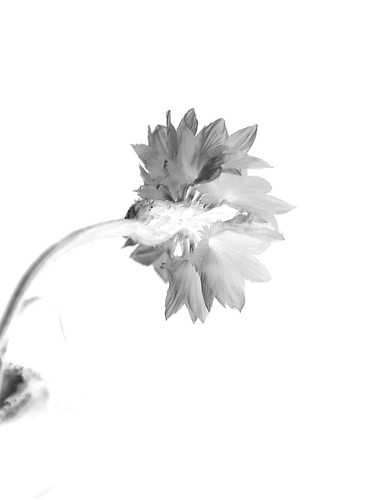
High Key is a style of lighting for film, television, or photography that aims to reduce the contrast ratio present in the scene. This was originally done partly for technological reasons, since early film and television did not deal well with high contrast ratios, but now is used to create an upbeat mood.

I was first introduced to the concept of High Key as part of an assignment on the Flickr Group Take a Class with Dave and Dave.

My submission to the assignment was a black and white high key of a cornflower.
Cornflower High Key
My camera at that time was my 5 year old Sony S85, which Medha now thinks is her camera and is doing a rather great job with.

My favorite submissions from other participants in that group were this, this and this. You can see all the submissions here.

I haven't been very successful with high key in color, therefore I am rather pleased with this attempt. What do you think?


In fact, so happy am I that I am sending it as an entry for Jai and Bee's first themed photo event, Click, where surprise! surprise! the theme is Eggs!

I knew what I wanted to do but I didn't quite know how to stand up the egg without the prop showing through. Any guesses on what I used? My husband - oh! is he out of the doghouse again or what?! ;-) - came up with the solution. What would I do without him?! Cos I was close to giving up.

I used a plain sheet of discarded drawing paper as the background and curved it up a bit to eliminate all the mess that lay on my dining table. I also tried to do as much in-camera editing by setting the exposure and shutter speed so that post-processing using Adobe Photoshop was limited to cropping, minor adjusting of levels and removal of some inadvertent drops of water that dampened the background paper as they were added to the cracked egg to make it flow over.

Camera: Sony DSLR A100
Lens: Kit lens 3.5-5.6/18-70 (birthday's coming up! Need to drop hints starting now! But I have to admit that for a kit lens, this lens rocks!)
Focal length: 70mm
Aperture: f6.3
Exposure time: 1/30
ISO: 400
White Balance: Sunny
Metering Mode: Spot
Post processing: Adobe CS

Saturday, September 08, 2007

Utah: Where the Ancients Once Roamed

On the spur of the moment - a euphemism for "we took too long to decide and got the last available room" - we drove to Moab, Utah for the long weekend. We pulled a reluctant Medha out of school - yes, she's crazy like that - and headed for the oven that was the high desert of Utah, where surface temperatures are 20-25F more than the air temperature. Our neighbors hid their smiles when we told them we were going. It was 100F in Moab all weekend long but we were armed with all the frozen water in the world and we had an incredible weekend.

The land formations are so unique and mind-blowing that the whole weekend was akin to a very spiritual experience, not unlike the one at the Grand Canyon. Where you are looking at millions of years of history of the Earth. Where it is driven home just how insiginficant man is. If there is a God, then this is the closest thing to being with God.

On a good day, Arches National Park, near Moab, Utah, is just 5 and half hours away from Louisville, Colorado. The park is filled with sandstone formations sculpted by the forces of nature - sun, wind, snow, rain and rock upheavals due to an unstable underground salt bed - into fins, balanced rocks and over 2000 arches.

The North Window

The Windows section has two large arches that frame the vistas behind them. They were a dull red till the sun broke out from behind the clouds. When this happens, the glowing landscape comes alive, draws you further into its magic as the play of light continues, and one can't but help wonder what the ancients made of this.

Sun Pillar at the Turret Arch

As the colors danced in the skies, I saw my first sun pillar emerge from the setting sun. This was turning into a spiritual experience for me and we had only just arrived there. Many of the ancients, especially the agrarian tribes, worshipped the sun. I wonder how they interpreted the sun pillars that shot into the evening skies.

Delicate Arch

Utah's most famous symbol, found everywhere and now prominently on vehicle license plates.

Edward Abbey, noted naturalist and author, wrote this: "There are several ways of looking at Delicate Arch. Depending on your preconceptions you may see the eroded remnants of a sandstone fin, a giant engagement ring cemented in rock, a bow-legged pair of petrified cowboy chaps, a triumphal arch for a procession of angels, an illogical freak, a happening.... If Delicate Arch has any significance it lies, I will venture, in the power of the odd and unexpected to startle the senses and surprise the mind out of their ruts of habit, to compel us into a reawakened awareness of the wonderful-that which is full of wonder."

The spirituality of this arch hits home when you consider that the same geological and natural forces that made this arch will also destroy it in time to come.

Balanced Rock

Balanced Rocks can be seen throughout Arches National Park. This Balanced Rock is the largest and is said to be the size of 3 schoolbuses! The caprock is made up of hard Slick rock whereas the pedestal is made of the softer Dewey Bridge mudstone. The softer pedestal weathers away more quickly than the resistant Slick rock. Eventually this formation will collapse due to the faster eroding Dewey Bridge.

Utah Juniper

Limited by lack of water, shrubs and trees must disperse in the desert to survive. Once established, these desert plants are tenacious and their roots can split rocks in their search for nutrients. Desert plants are smaller than their non-desert counterparts; their leaves furled or spiny in order to reduce surface area through which water is lost. A 30 year old tree may only be a few feet tall. The Utah juniper is often called the classic desert tree. Its twisting, often-dead branches speak vividly of life with scarce water. A juniper is known to stop the flow of fluids to its outer branches in order to give the tree a better chance for survival. Scale-covered leaves and bluish, waxy-coated berries help the tree conserve moisture. The juniper berries are actually closed cones and whether you believe me or not, the Visitor Guide to Arches National Park says "they're actually tiny pinecones". Having been chastised for repeating that, I make sure I drop the word pine!

It's hard to believe but there are wildflowers of beautiful colors in the desert. The ancients dug up roots for water and knew exactly which berries to eat and which to leave for the birds. They hunted rabbits with long ears, that reflected the harsh sun and conserved water. They, too, like the plants adapted to the desert conditions. Watch my Flickr photostream for ad nauseum pictures of this trip. As of writing this, I still have a whole bunch left to upload.

Ancient Petroglyphs

Panels of petroglyphs dating back to between 600 and 1300AD line the scenic byway 279. These are etchings or peckings into the red sandstone depicting warriors, mountain sheep, bison, deer, horsemen, snakes, rivers and geometric designs. Archaeologists believe that the older panels were the work of the Southern San Rafael Fremont, and included animals, lines of hand-holding men, triangular-bodied figures with weapons like spears and shields. The more modern petroglyphs are the work of the Ute, with less attention to detail and less weathering than those of the Fremont.

Dead Horse Point

Dead Horse Point is a spectacular natural corral that towers 2000ft over the Colorado River as it goosenecks through the landscape of pinnacles and buttes it has carved over millions of years. In a state park by the same name, it is about 40 miles from Moab.

Dead Horse Point is on a mesa or plateau at an altitude of 6000ft. We were quite comfortable breathing there as we live at 5500ft.

"From the point, layers of geologic time may be viewed, revealing 300 million years of the Earth's geologic history. While standing on the canyon rim, 8000ft of geologic strata is visible looking from the peaks of the 12000ft La Sal Mountains to the river below. These rock layers were deposited over the eons by oceans, fresh water and wind, as well as igneous events" (From the Visitor Guide to Dead Horse Point State Park).

The name has arisen from a legend that cowboys would herd wild mustangs that roamed the mesa into this natural corral, linked to the main plateau by a neck only 30 yards wide, and then close off the neck with brush and branches. They would then select the horses they wanted. On one occasion, they left the horses they did not want corralled on the waterless point and these magnificient horses died of thirst looking down at the Colorado River, 2000ft below.

Green River and Canyonlands

Green River is one of Colorado River's main tributaries that begins in the Wind River Range of Wyoming. It is known to gooseneck for over 5 miles while moving ahead only 1 linear mile.

"Evidence of Utah’s ancient inhabitants can be found in the Green River Utah Basin, which was once home to the Fremont Culture. The Fremont Native Americans were a semi-nomadic people, who were known for their distinctive pottery, figurines and rock art which can be found on canyon walls and in overhangs throughout the river basin. They inhabited the area from 600 A.D. to 1200A.D. Years later, the Utes would occupy the Green River Utah Basin. Today, they still inhabit the area. Their reservation is in the Uinta Basin." (From Destination 360)

View a Slideshow of these images and click through to the photo page to View them Large on Black.

If you would like to re-publish this Photo Essay or publish any of my images from this blog or from my Flickr photostream, please get in touch with me by email polarmate [at] gmail [dot] com.

About This Blog

  © Blogger template 'Photoblog' by Ourblogtemplates.com 2008

Back to TOP